
2018 Adventures
I can hardly believe it, the sun is out today.. might be intermittent but it still seems like an illusion in the distant sky.
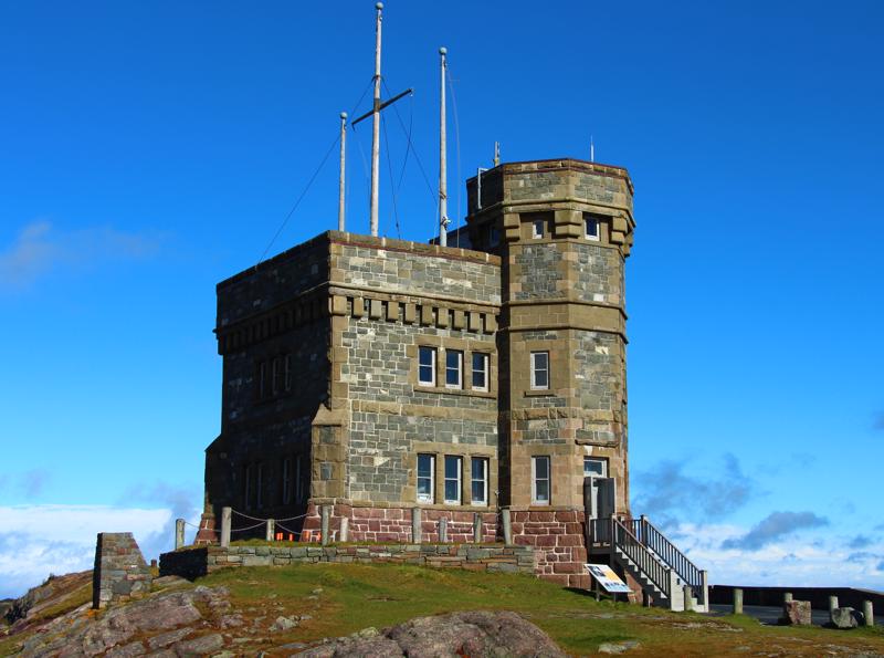
We hopped into the car to and headed up to the Signal Hill Historic Site and Cabot Tower. Dominating the skyline and located overlooking the narrow entrance to St. John’s harbour, Signal Hill has been a key part of this province’s military and communications history and has shaped Newfoundland’s place in the world.
On June 27, 1762, during the Seven Year’s War, St. John’s found
brenda stanger
104 chapters
16 Apr 2020
Newfoundland - St. John's
Day 3 - St. John's
I can hardly believe it, the sun is out today.. might be intermittent but it still seems like an illusion in the distant sky.
We hopped into the car to and headed up to the Signal Hill Historic Site and Cabot Tower. Dominating the skyline and located overlooking the narrow entrance to St. John’s harbour, Signal Hill has been a key part of this province’s military and communications history and has shaped Newfoundland’s place in the world.
On June 27, 1762, during the Seven Year’s War, St. John’s found
itself under attack by French forces under the command of the Comte d’Haussonville. After successfully capturing St. John’s, Comte d’Haussonville then took over the area and based his forces around Signal Hill.
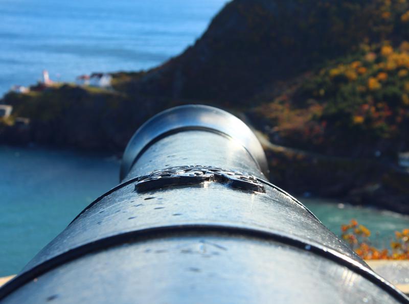
The Battle of Signal Hill took place on the morning of September 15 that same year when the 200 English soldiers climbed Signal Hill attacking 295 French infantry. The attack, which caught the French by surprise, resulted in the French forces retreating and surrendering three days later. The Battle of Signal Hill was the final battle of the Seven Year’s War in North America, which secured Great Britain as the prominent European power in North America.
In 1897, Cabot Tower was commissioned to commemorate the 400th anniversary of John Cabot’s discovery of Newfoundland and Queen Victoria’s Diamond Jubilee. An excellent example of late-gothic
revival architecture the tower was designed by St. John’s architect William Howe Greene.
In 1901, Signal Hill was at the centre of a major international breakthrough. Guglielmo Marconi, using an antenna suspended 500 feet by kite, received the first transatlantic wireless signal, the letter ‘S’ in Morse code. Marconi’s breakthrough, which was part of an ongoing rivalry with many inventors, led to a new age in communication technology.
The views from Signal Hill of St. John's is simply amazing. On such a clear day you can see clear across the narrow channels and far across the ocean.
From Signal Hill we went headed around the back side of the bay to
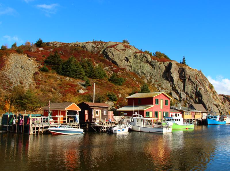
visit Quidi Villi Village, a historic fishing village just beyond Quidi Vidi Lake. This is where the famous annual St. John’s Regatta takes place each summer.
The village is a little sheltered corner of the east coast, with a glimpse of the Atlantic Ocean from inside the gut. Quidi Vidi Village was used after World War II for the construction of the United States’ Air Force Base. Nowadays, however, the village is a quiet community, where you can walk from one end to the other in five minutes flat.
Quidi Vidi Village’s biggest charms are the antique shop, Quidi Vidi Inn of Olde and the Quidi Vidi Village Plantation. Standing on its own picturesque wharf in an iconic fishing community, the Quidi Vidi Village Plantation is a craft enterprise incubator for emerging artists and a destination for those wishing to explore a unique corner of the oldest cities in North America. Built to reflect the fishing stages and fish plants of the 1600's the Plantation welcomes visitors to watch, interact with and support local craftspeople as they produce unique handmade items in a wide variety of mediums. The area is only a few minutes away from downtown St. John's but still has a quaintness of the old fishing village.
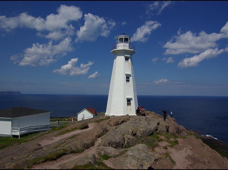
Cape Spear was our next stop, just around the other side of the bay and on the other side of St. John's. Jutting out into the cold and violent North Atlantic, Cape
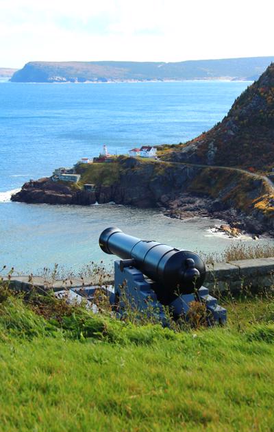
Spear is the most easterly point of North America. Originally named “Cabo da Esperança” by Portuguese sailors, then “Cap d’Espoir” by the French, and eventually Cape Spear by the English, this point of land has been an important navigational aid from the earliest days of Newfoundland’s exploration to the present.
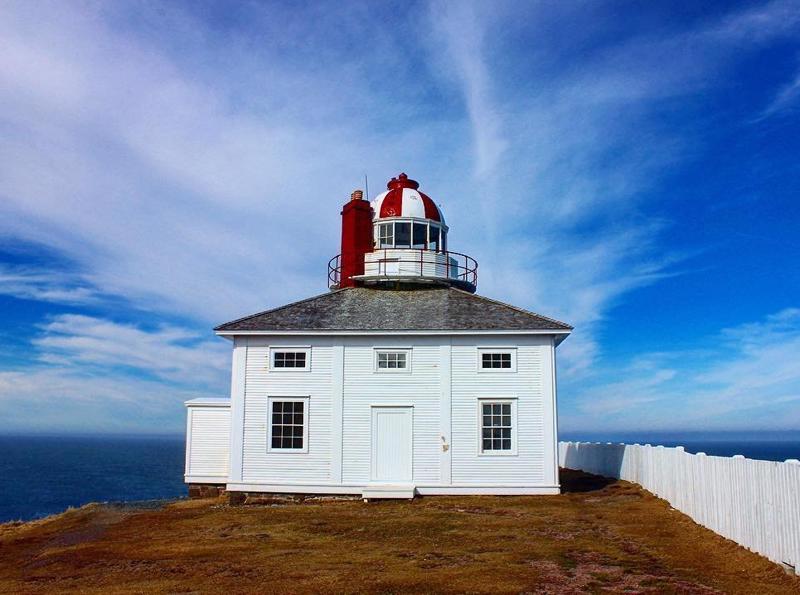
Built in 1836, Cape Spear features Newfoundland’s oldest surviving lighthouse, which is based on a square two story building with the tower and light in the middle. The light and technology in the lighthouse changed over time until 1955 when a new concrete lighthouse became operational. As it stands now the lighthouse has been restored to its 1839 appearance and is set up to show how a mid-nineteenth century lighthouse keeper and his family would have lived.
Cape Spear’s location near the convoy routes of the Second World War made it a strategic point in the Battle of the Atlantic. To provide protection for convoys from German submarines a battery and garrison was stationed at Cape Spear featuring bunkers, underground passages, and two 10-inch guns. Today this outpost is no longer used by any military and the remains of the bunker stand as a reminder of the impact of the war.
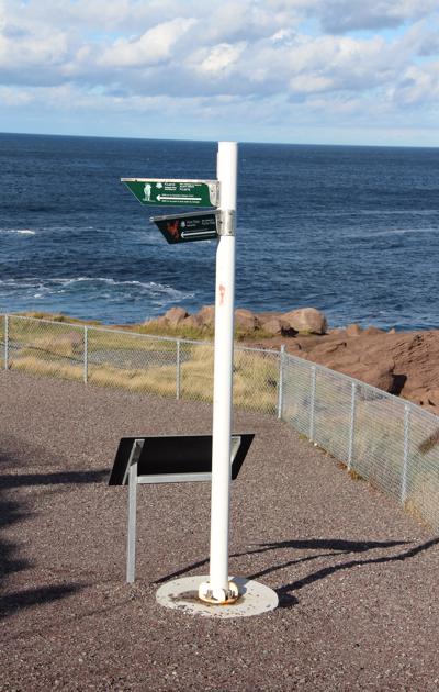
Along with its history Cape Spear is an excellent place to see seabirds, icebergs, ships, and whales in the spring and summer months. Sightings have included Dolphins, Humpback Whales, and even on rare occasions Orca Whales. Along with its opportunities to see wildlife on the sea and land the East Coast Hiking Trail passes through Cape Spear, offering access to some of the island’s best hiking trails.With its outstanding history, natural environment, and outdoor activities Cape Spear is a must see for any visitor and a
treasure for any local to enjoy.
When we were in South Africa we took a drive down the Cape of Good Hope and visited South Africa's most southern point -Cape Agulhas (about 150 km east of the Cape of Good Hope). The Cape marks the boundary between the Atlantic and Indian Oceans. The clash of warm and cold ocean currents often leads to violent waves and was feared by the seafarers. In the same trip we also had been to Africa's highest peak - Mount Kibo at 5895 metres (within the Kilamanjaro mountain range).
Now that we have been to North America's most easterly point (and Canada's as well), we have to make plans to visit the most westerly point in North America to cover both ends of the country.
North America/Canada's significant markers are:
Northernmost point — Cape Columbia, Ellesmere Island, Nunavut
Southernmost Canadian point — South point of Middle Island, Ontario, Lake Erie
Easternmost point — Cape Spear, Newfoundland
Westernmost point — Boundary Peak 187, Yukon
What a beautiful day for a drive. We really are starting to discover the history of Newfoundland and all that it has to offer.
1.
Year of Travel
2.
Sosua - Dominican Republic
3.
Our Adventures So Far...
4.
Beach Life
5.
Our Favourite Restaurants in Sosua
6.
Fun with Friends
7.
Sosua Continued
8.
Sun, Surf and Sand
9.
Samana Peninsula
10.
Sosua Highlights
11.
USA Road Trip
12.
Texas
13.
Texas
14.
Louisiana - NOLA
15.
Louisiana - NOLA
16.
Louisiana - NOLA
17.
Alabama
18.
Alabama to Tennesse
19.
Tennesse - Nashville
20.
Tennesse - Nashville
21.
Tennesse - Nashville
22.
Tennesse - Memphis
23.
Tennesse - Memphis
24.
Tennesse - Memphis
25.
Summer at Home
26.
Westcoast Adventures
27.
Europe
28.
Europe - Budapest
29.
Europe - Budapest
30.
Europe - Vienna
31.
Europe - Vienna
32.
Europe - Vienna
33.
Europe - Prague
34.
Europe - Prague
35.
Europe - Prague
36.
Europe - Berlin
37.
Europe - Berlin
38.
Europe - Berlin
39.
Europe - Salzburg
40.
Europe - Salzburg
41.
Europe - Salzburg
42.
Europe - Salzburg
43.
Europe - Salzburg
44.
Europe - Innsbruck
45.
Europe - Innsbruck
46.
Europe - Bad Ragaz
47.
Europe - Bad Ragaz
48.
Europe - Lindau
49.
Europe - Lindau
50.
Europe - Fussen
51.
Europe - Fussen
52.
Europe - Freising and Munich
53.
San Francisco
54.
San Francisco
55.
San Francisco
56.
San Francisco
57.
San Francisco
58.
San Francisco
59.
Canada Road Trip
60.
On the Road to Ontario
61.
Ontario - Thunderbay
62.
Ontario - Thunderbay
63.
Ontario - Thunderbay
64.
Ontario - Toronto
65.
Ontario - Ottawa
66.
Ontario - Ottawa
67.
Quebec - Montreal
68.
Quebec - Montreal
69.
Quebec - Montreal
70.
Quebec - Quebec City
71.
Quebec - Quebec City
72.
Quebec - Sainte Flavie
73.
New Brunswick - Bathurst
74.
New Brunswick - Shediac
75.
New Brunswick - Shediac
76.
Prince Edward Island - Charlottetown
77.
Prince Edward Island - Road trip
78.
Prince Edward Island - Charlottetown
79.
Prince Edward Island - More exploration
80.
Nova Scotia - Halifax
81.
Nova Scotia - Halifax
82.
Nova Scotia - Halifax
83.
Nova Scotia - Sydney
84.
Newfoundland - Channel-Port
85.
Newfoundland - Rocky Harbour
86.
Newfoundland - Rocky Harbour
87.
Newfoundland - St. John's
88.
Newfoundland - St. John's
89.
Newfoundland - St. John's
90.
Newfoundland - St. John's
91.
Newfoundland - St. John's
92.
Newfoundland - Travelling
93.
Nova Scotia - Sydney
94.
New Brunswick - Saint John
95.
Maine - Portland
96.
Massachessets - Cape Cod via Boston
97.
Massachusetts - Cape Cod
98.
Massachusetts - Cape Cod
99.
Pennsylvania - Clearfield
100.
Illinois - Chicago
101.
Illinois - Chicago
102.
Illinois - Chicago
103.
Heading Home
104.
Our Year at a Glance
Share your travel adventures like this!
Create your own travel blog in one step
Share with friends and family to follow your journey
Easy set up, no technical knowledge needed and unlimited storage!
© 2025 Travel Diaries. All rights reserved.