
2018 Adventures
AirBnB accommodations: $$192.17 CAD for 2 nights (taxes, fees and cleaning fee inclusive)
Sydney was founded in 1785 and named in honour of Britain’s Home Secretary at the time, Thomas Townsend, 1st Viscount Sydney; a few years later, Sydney, Australia would also be named after him. Sydney's original settlers included former soldiers and Loyalists escaping the chaos following the American Revolution. The town was the English capital of Cape Breton Island from its founding until 1820, when the island colony and its rich coal fields became part of Nova
brenda stanger
104 chapters
16 Apr 2020
Nova Scotia - Sydney
Sydney
AirBnB accommodations: $$192.17 CAD for 2 nights (taxes, fees and cleaning fee inclusive)
Sydney was founded in 1785 and named in honour of Britain’s Home Secretary at the time, Thomas Townsend, 1st Viscount Sydney; a few years later, Sydney, Australia would also be named after him. Sydney's original settlers included former soldiers and Loyalists escaping the chaos following the American Revolution. The town was the English capital of Cape Breton Island from its founding until 1820, when the island colony and its rich coal fields became part of Nova
Scotia. It was that coal that would transform Sydney from a colonial town in Cape Breton into a major industrial center, becoming a world leader in steel production. That industrial growth saw Sydney officially become a city in 1904, welcoming workers and their families from around the province and world.
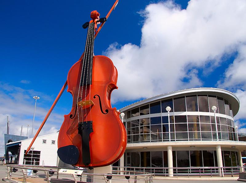
Today, Sydney continues to welcome people from around the world as they come to visit the city and the beautiful island of Cape Breton. Situated alongside the Joan Harriss Cruise Pavilion we discovered the world's largest fiddle. Standing at a height of 60 feet/18.3 metres tall, the Fidheal Mhor A’ Ceilidh, Gaelic for the Big Fiddle of the Ceilidh, greets cruise ship passengers and visitors to Sydney, Cape Breton Island from its home on the waterfront. You can hear the music playing from the fiddle right around the waterfront. Pretty amazing.
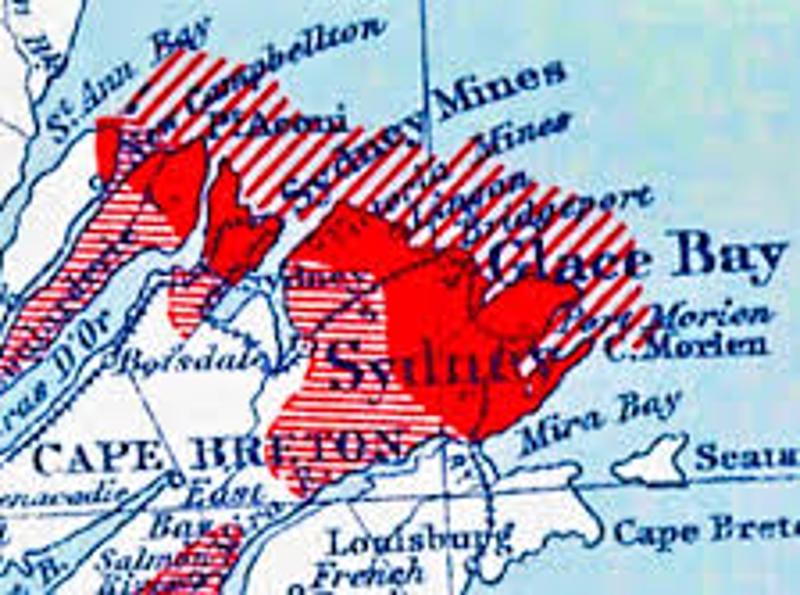
Before we headed to Newfoundland we travelled from Halifax up to Sydney. We travelled up the west side of the island at that time, taking in part of the Cape Breton Highlands and part of the Cabot trail. Today we decided to take a journey along the north east corner of Cape Breton to see some of the coal mining history that Cape Breton is known for.
Starting in Whitney Pier, the Colliery Route (Route 28) we followed the east side of Sydney Harbour north toward the Atlantic Ocean. After passing through South Bar, Victoria Mines and Low Point, Route 28 bears right at the harbour entrance to the town of New Waterford (pop. 7,705). Named after the port of Waterford in Ireland, which sent many Irish immigrants to Cape Breton, the first coal was mined there in 1854.
Over the years a total of 11 undersea mines operated in the vicinity, with the last one closing in 1999. On our right, when we entered the town, the Colliery Lands Park pays tribute to the 298 men and boys killed in the local collieries. The largest loss of life occurred in No. 12 colliery on July 25, 1917 when 65 individuals ranging in age from 14 to 65 were killed in a massive explosion caused by an accumulation of coal dust. There were 205 survivors.
The park, which is home to the New Waterford Historical Society, features an exposed coal seam, equipment displays and a memorial with 15 flags, representing the various nationalities of the people who lost their lives underground, or under the ocean.
Next stop along the route is Lingan, home to the largest power plant in the province of Nova Scotia. Opened in 1979, at the height of the
1970s oil crisis, it was designed to burn coal from the nearby mines. With the end of mining on Cape Breton, the plant now burns imported coal from the United States and South America. It provides 25 per cent of Nova Scotia's electrical power.
Just a short distance away Route 28 enters Glace Bay (pop. 16,984), at one time the location of the largest submarine coal mining operation in the world. The town's first mine opened in 1857, and for many years it was the heart of the coal industry in Cape Breton, with as many as 11 collieries in operation at any one time. The last mine closed in 2001, but a fascinating Miner's Museum offers visitors a chance to put on a hard hat, complete with lamp, and experience what it was like to work underground. This town received its name from 16th century French fishermen, who arrived in early spring to find the harbour full of pack ice. They named the place Glace Bay (Bay of Ice), and returned each season for the next two centuries to
harvest the bountiful fishing grounds that were close by.
After Glace Bay we continued on in our journey to Fort Louisbourg and explore its history dating back hundreds of years. When the War of Spanish Succession was settled with the Treaty of Utrecht in 1713, Britain was given control of mainland Nova Scotia and France was given Ile Royale, what is today known as Cape Breton Island.
On the eastern side of Cape Breton, the French found an ice-free, sheltered harbour to act as a base for France’s interests in the cod fishery and to serve as an important trading outpost because of its proximity to Europe and colonies in both New England and the West Indies. They named it Louisbourg, in honour of King Louis XIV.
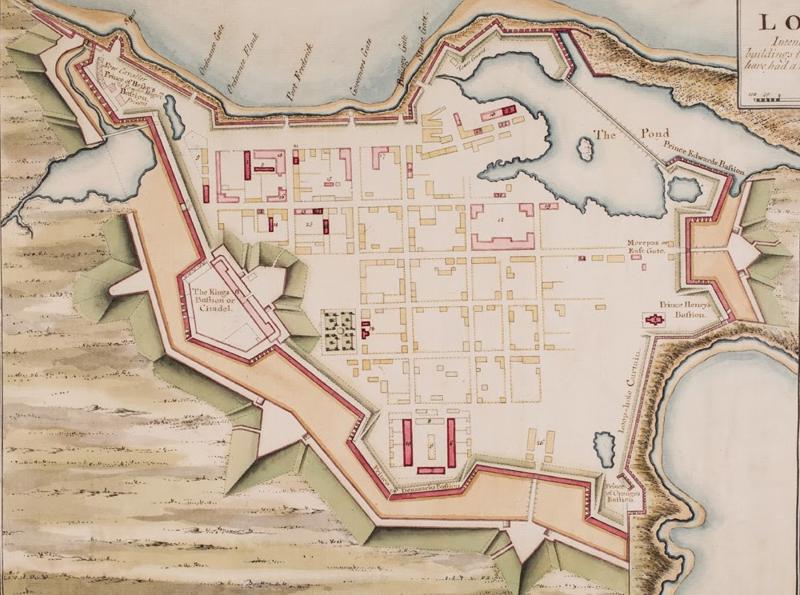
Over the course of almost three decades, engineers surrounded the
town and garrison with massive stone walls that would make it one of the most extensive fortifications in North America. In fact, the 4 kilometres (2.5 miles) of walls – measuring 30 feet high and 36 feet thick in some places – cost so much to build that the French king joked how he expected to be able to see them from his palace in France.
Despite the towering walls, the Fortress of Louisbourg had some weaknesses that its engineers struggled with. While the fortress was well defended against attacks from the sea, it was vulnerable to land-based assaults, and when France and Britain went to war in 1745, this weakness was exploited. The attackers – New England militia who saw Louisbourg as a direct threat to their colonies and the nearby fishing grounds – erected siege batteries on the hills overlooking the fortress and, through a series of bombardments and assaults, forced the defenders to surrender.
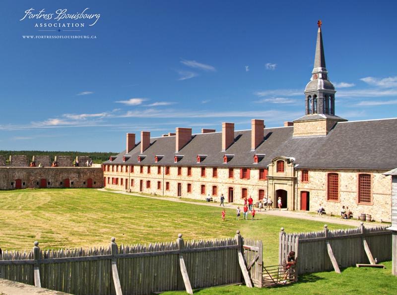
Even with its proud military heritage, the Fortress of Louisbourg was about more than just the military. At its core, Louisbourg was a thriving civilian community made prosperous by a profitable cod-fishery and strong trade ties reaching across the Atlantic. During its peak it was the third busiest port in North America and was considered the jewel of France’s holdings in the new world. Louisbourg represented hope, and its prosperity convinced many of France’s poor and impoverished to leave their homes behind and seek a chance at a better life.
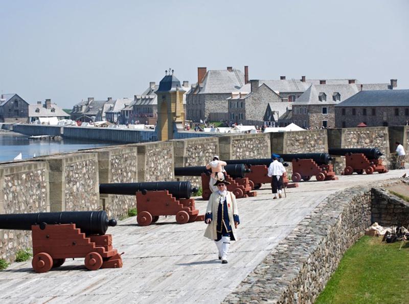
The Fortress of Louisbourg might have been lost to history had it not been designated a National Historic Site and partially reconstructed in the 1960s. It has become the largest reconstructed 18th-century French fortified town in North America, with archaeologists, and engineers and historians working together to recreate the town as it was in the 1740s era.
It is a pretty impressive area to explore! Being that we are in the "winter" months, only a few of the exhibits are open. You can wander around town and really envision what it would be like to live in the old town.
What a great day of exploration! After the Fortress of Louisbourg we headed back to Sydney. A stir-fry for dinner and settled in for the night. Tomorrow we head to Saint John, NB and slowly make our way down the east coast.
1.
Year of Travel
2.
Sosua - Dominican Republic
3.
Our Adventures So Far...
4.
Beach Life
5.
Our Favourite Restaurants in Sosua
6.
Fun with Friends
7.
Sosua Continued
8.
Sun, Surf and Sand
9.
Samana Peninsula
10.
Sosua Highlights
11.
USA Road Trip
12.
Texas
13.
Texas
14.
Louisiana - NOLA
15.
Louisiana - NOLA
16.
Louisiana - NOLA
17.
Alabama
18.
Alabama to Tennesse
19.
Tennesse - Nashville
20.
Tennesse - Nashville
21.
Tennesse - Nashville
22.
Tennesse - Memphis
23.
Tennesse - Memphis
24.
Tennesse - Memphis
25.
Summer at Home
26.
Westcoast Adventures
27.
Europe
28.
Europe - Budapest
29.
Europe - Budapest
30.
Europe - Vienna
31.
Europe - Vienna
32.
Europe - Vienna
33.
Europe - Prague
34.
Europe - Prague
35.
Europe - Prague
36.
Europe - Berlin
37.
Europe - Berlin
38.
Europe - Berlin
39.
Europe - Salzburg
40.
Europe - Salzburg
41.
Europe - Salzburg
42.
Europe - Salzburg
43.
Europe - Salzburg
44.
Europe - Innsbruck
45.
Europe - Innsbruck
46.
Europe - Bad Ragaz
47.
Europe - Bad Ragaz
48.
Europe - Lindau
49.
Europe - Lindau
50.
Europe - Fussen
51.
Europe - Fussen
52.
Europe - Freising and Munich
53.
San Francisco
54.
San Francisco
55.
San Francisco
56.
San Francisco
57.
San Francisco
58.
San Francisco
59.
Canada Road Trip
60.
On the Road to Ontario
61.
Ontario - Thunderbay
62.
Ontario - Thunderbay
63.
Ontario - Thunderbay
64.
Ontario - Toronto
65.
Ontario - Ottawa
66.
Ontario - Ottawa
67.
Quebec - Montreal
68.
Quebec - Montreal
69.
Quebec - Montreal
70.
Quebec - Quebec City
71.
Quebec - Quebec City
72.
Quebec - Sainte Flavie
73.
New Brunswick - Bathurst
74.
New Brunswick - Shediac
75.
New Brunswick - Shediac
76.
Prince Edward Island - Charlottetown
77.
Prince Edward Island - Road trip
78.
Prince Edward Island - Charlottetown
79.
Prince Edward Island - More exploration
80.
Nova Scotia - Halifax
81.
Nova Scotia - Halifax
82.
Nova Scotia - Halifax
83.
Nova Scotia - Sydney
84.
Newfoundland - Channel-Port
85.
Newfoundland - Rocky Harbour
86.
Newfoundland - Rocky Harbour
87.
Newfoundland - St. John's
88.
Newfoundland - St. John's
89.
Newfoundland - St. John's
90.
Newfoundland - St. John's
91.
Newfoundland - St. John's
92.
Newfoundland - Travelling
93.
Nova Scotia - Sydney
94.
New Brunswick - Saint John
95.
Maine - Portland
96.
Massachessets - Cape Cod via Boston
97.
Massachusetts - Cape Cod
98.
Massachusetts - Cape Cod
99.
Pennsylvania - Clearfield
100.
Illinois - Chicago
101.
Illinois - Chicago
102.
Illinois - Chicago
103.
Heading Home
104.
Our Year at a Glance