
GHUMAKAD
Driving on Indian roads is like walking on a tight rope. You've got to be really careful with the wheels because of pathetic road conditions that could test the patience of even the most seasoned drivers. But you really deserve a medal if you've driven on the following Indian roads and highways. These are literally multiple highways to hell.
The best part about reaching a destination is the journey. These roads from a country of one of the largest road networks are so thrilling that you’ll never get enough of your expeditio.
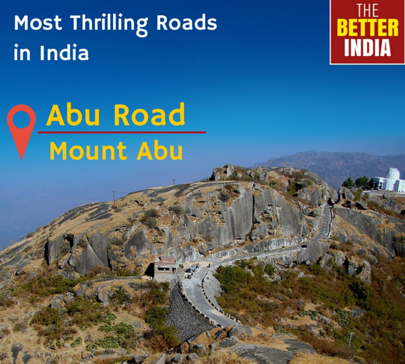
Mount Abu is a renowned hill station, situated in the barren land of Rajasthan State. The city is located at a height of 1,220 meter above sea level, and has a stretch of 22 kilometer length and 9 kilometer width. “Guru Shikhar” is the highest point at Mount Abu and in the Aravalli Range, which is 1,772 meters above sea level. To reach Mount Abu one has to pass through 28 Kilometer road which starts from Abu road.
caamitstotala
2 chapters
16 Apr 2020
Most Thrilling Roads in India.
April 29, 2016
|
INDIA
Driving on Indian roads is like walking on a tight rope. You've got to be really careful with the wheels because of pathetic road conditions that could test the patience of even the most seasoned drivers. But you really deserve a medal if you've driven on the following Indian roads and highways. These are literally multiple highways to hell.
The best part about reaching a destination is the journey. These roads from a country of one of the largest road networks are so thrilling that you’ll never get enough of your expeditio.
Mount Abu is a renowned hill station, situated in the barren land of Rajasthan State. The city is located at a height of 1,220 meter above sea level, and has a stretch of 22 kilometer length and 9 kilometer width. “Guru Shikhar” is the highest point at Mount Abu and in the Aravalli Range, which is 1,772 meters above sea level. To reach Mount Abu one has to pass through 28 Kilometer road which starts from Abu road.
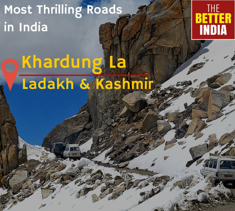
Listed in Guinness book of world records, Khardung La pass is believed to be the highest motor-able road in the world. Local inhabitants claim that its actual height is 5,602 meter while its actual height is 5,359 meters above sea level. It is situated in Ladakh region of Jammu and Kashmir State in India. These roads are not paved and are slippery due to the frozen ice and dirt mix. The road has a narrow trail with deep valleys on one side.
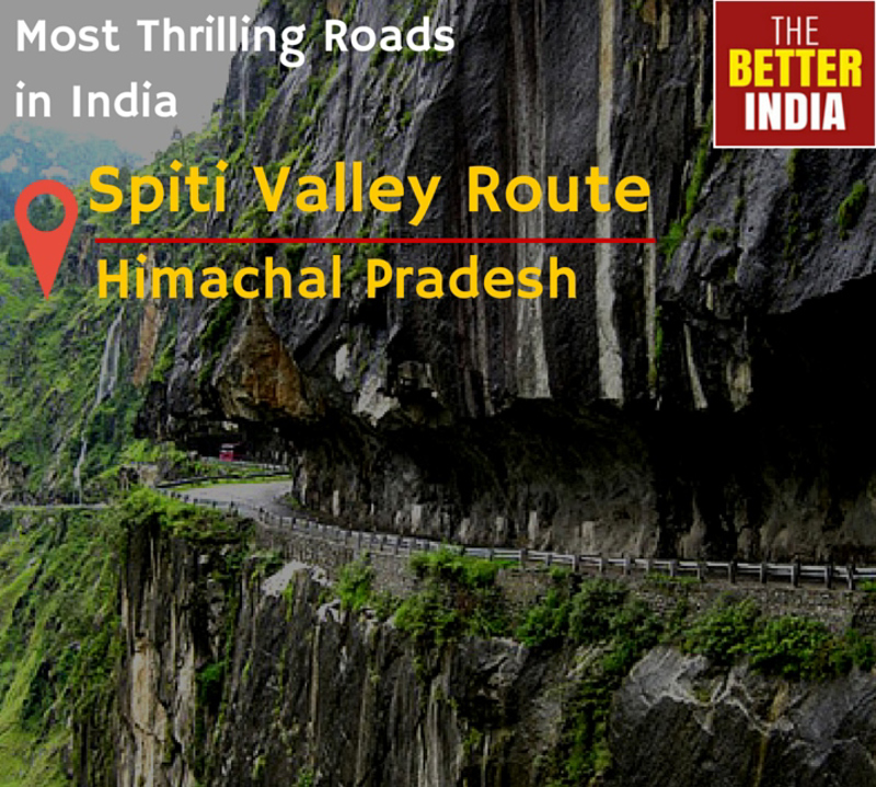
The Spiti Valley route in east of Himachal Pradesh is geographically not far away from Ladakh, but it is not that famous as the above rout However the route isn’t any way behind in terms of natural beautiful landsape and awe-inspiring roads. The Hindustan-Tibet highway is the road that leads into Spiti valley and it surely makes your adrenalin keeps flowing on the ride.
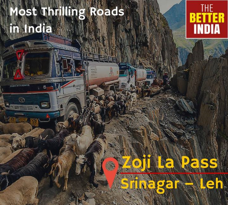
At an altitude of 3,538 meters above sea level, Zoji La Pass is one the important and most dangerous mountain pass in the India. The pass is traversed by Srinagar-Leh Highway. The road is very narrow and easily gets muddy during rains and becomes impassible during or after Storms.
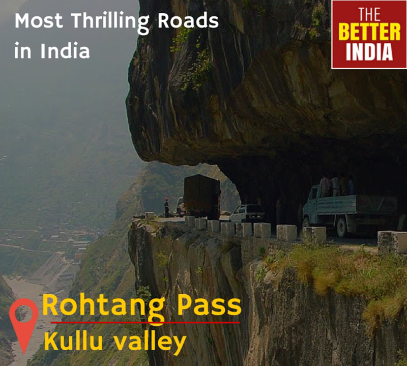
Rohtang Pass is at an elevation of 3,979 mt above sea level and is located on the eastern Pir Panjal range of Himalayas. The path is situated about 53 km from Manali and is crossed by Leh-Manali Highway. It connects the Kullu valley with the valleys of Lahaul and Spiti.
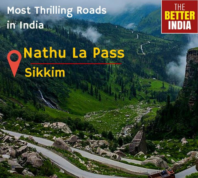
Connecting the Indian state of Sikkim with China, Nathu La is a mountain pass in the Himalayas. It is one of the three trade link between India and China. The pass is at 4,310 Meter above sea level and is one of the highest pass accessible via road. Nathu means “Listening ears” whereas La means “Pass”.
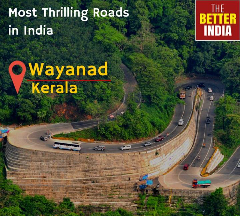
Wayanad District is a district in the north-east of Kerala state. Wayanad district is in the southern tip of the Deccan Plateau. Part of the Western Ghats is in the district. In the centre of the district hills are lower in height while the northern area has high hills. The eastern area is flat and open. 'The Land of Paddy Fields'. There are many indigenous tribals in this area.It is set high on the Western Ghats with altitudes ranging from 700 to 2100 m.It is the least populous district in Kerala.
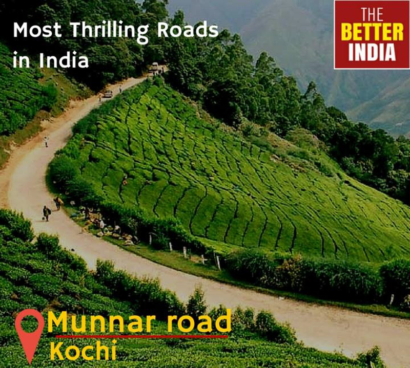
Munnar road is a 130 Kilometer pass, staring from Kochi to Munnar. Munnar is a Hill station in State of Kerala at an elevation of 1,700 meters above sea level. Munnar is located in the Western Ghats, in Idukki district. The road to Munnar is sharply winding, steep and also has narrow zigzags. The road is surely breathtaking and also has a fearsome reputation.
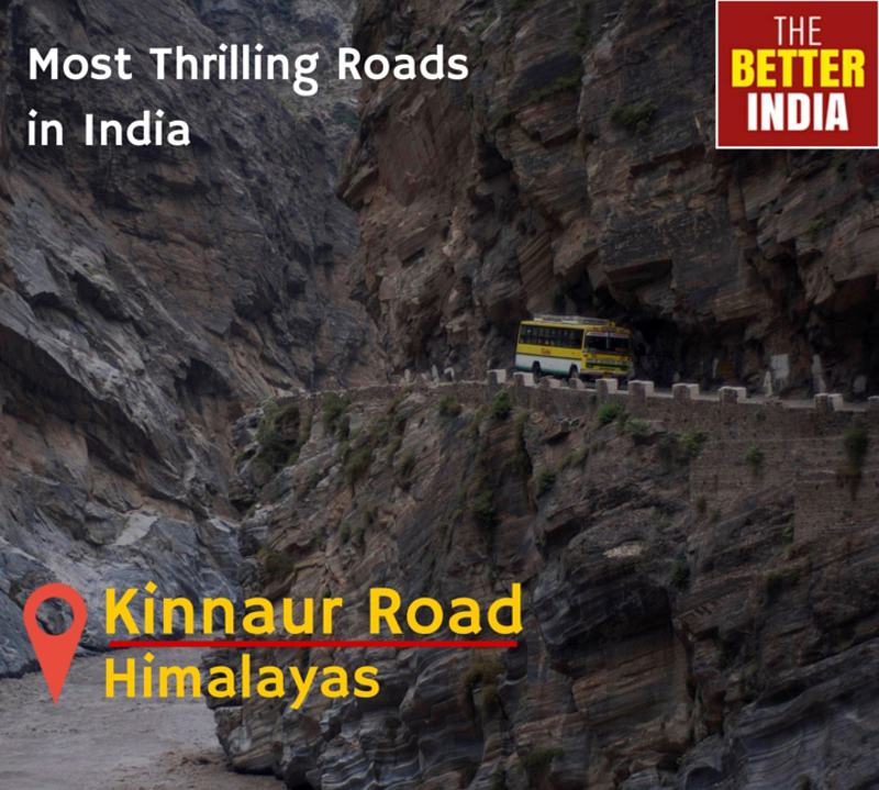
Kinnaur Road is a scenic cliff-hanging drive through the seemingly bottomless Baspa river gorge in Sangla Valley in Kinnaur district of Himachal Pradesh, India. It is located in the southeastern part of the state, and borders Tibet on its eastern end. Kinnaur Road has been cut into hard rock, to make a road linking Kinnaur and the rest of the country. Most of the villages of Kinnaur lie at quite a high altitude, some close to 4000m. It's a dry and very cold area, and in the right season (July-August) its quietness, great visibility, wonderful views and somewhat mysterious atmosphere all make it a great area to explore.
Share your travel adventures like this!
Create your own travel blog in one step
Share with friends and family to follow your journey
Easy set up, no technical knowledge needed and unlimited storage!